A Shropshire Hills Microadventure

A Foggy Start

A foggy start for Beppe

The plan for this microadventure was quite simple: start an hour’s drive away at the base of one of Shropshire’s highest hills, summit the aforementioned hill, then walk 7 miles north cross-country to summit one of its neighbours. Upon reaching this goal we (‘we’ being myself and Beppe, my Italian Talitubby lookalike friend) intended to eat, drink, make merry, beat our chests and roar like a couple of bull seals fighting over a prize female. Having got this out of the way we’d bivvy overnight before completing the return journey early next morning, heading straight to work and thrilling our colleagues with tales of derring-do.

All this sounded perfectly straightforward and foolproof, which is just another way of saying that things were bound to – and indeed did – go wrong. Thankfully, serendipity saved the day and the aborted version of this microadventure was probably more enjoyable than a successful run-through. The initial frustration of having a goal thwarted (by circumstances entirely outside our control) soon gave way to humour and I for one was giggling like a demented little monkey on the return journey. All-in-all a firm “thumbs up” for the concept of microadventure!

The start was easy enough, although we arrived in thick fog and it was fairly difficult to locate a clear path to the summit. I decided to improvise a route instead and join the trail halfway up, and after an unnerving scramble up a very steep berm covered in loose rock and soil this was duly accomplished. Visibility at the summit’s trig point averaged about 30ft and my 1:50,000 scale map wasn’t much help in terms of identifying the trail we needed to pick up for the descent down the other side. Of necessity I turned to my compass for assistance, and after taking and walking a bearing for a few minutes the practically non-existent path became a little clearer and more defined.

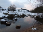
Strange shapes – golf ball radar installations – loomed out of the fog during the descent,  visible one minute, obscured the next. The equipment powering them seemed to emit a low volume/high pitch hum which helped contribute to a rather eerie, surreal atmosphere. The fog lifted about halfway down and the skies began to clear too, so we were provided with a decent view of the valley below and the route ahead. We were shocked at the amount of snow and standing water on the ground. As city boys we simply never imagined that we’d have to battle through snow and snow melt arising from the unseasonably severe weather that hit the UK three weeks’ prior to our trip.

To cut a long story short we set out at 7pm expecting to cover the 7 miles to our destination in no more than 2 hours. It actually took 4 hours and we arrived at 11pm. The extra two hours was spent either skirting round or attempting to climb over (or, more often than not, through) massive banks of snow and pools of standing water. One particularly bad 1km section took 50 minutes to complete. To add insult to injury we subsequently discovered that some clear sections of trail appeared to be the feeding ground for scores of small toads. It was dark by this time and we had to tiptoe around them by torchlight to avoid becoming the perpetrators of an amphibian holocaust.

DSCF2994b

Upon reaching our destination I immediately brewed up and my friend and I discussed our options. It seemed futile to break out our bivvi bags given that we’d have to set off no later than 2.30am to reach the car and drive back in time for work. It just didn’t seem worthwhile getting our gear out and getting it wet only to pack it all away again a few hours later. Nor did we fancy our chances of actually getting any sleep knowing that we had to get up in a matter of hours. With this in mind, and with some food and a hot drink inside us, we set off at 11.30pm to tackle the snow, water and toads all over again.

Lots of snowy goodness

Lots of snowy goodness

Having really pushed myself with a sprint interval session the day before I found the walk back really tiring. I got the giggles at one point while pushing hard on a long, seemingly never-ending incline that loaded my poor calf muscles with what felt like gallons of lactic acid. The discomfort was actually funny – you know how it is when you’re tired. The snowy sections (which we viewed as a damn nuisance on the outbound journey) provided another source of amusement and added to the sense of adventure. By this time it was past 2am and everyone we knew was safe and warm in bed, yet here we were in the middle of nowhere struggling through deep snow with only toads, owls, and the odd sheep for company.

Pausing for a brief break before starting off on the final leg we turned off our head torches and allowed our eyes to become accustomed to the dark. With clear skies the view overhead was simply stunning. So what if we were cold, wet and tired? Dragging ourselves away from this we soon reached our original start point, which once again was draped in thick fog from about the 1,000ft point onwards. Despite a slight navigational hiccup (my bad – always trust the compass!) we got back to the car just after 3am. I crawled into bed two hours later, tired but satisfied with the night’s exertions. And looking forward to a whole two-and-a-half hours’ sleep before work…

More microadventure please!

Trail Run Hell: A Post Mortem

Yesterday’s trail run – though no longer than usual at 16.5 miles in total – was an absolute nightmare. In fact the last 2 or 3 miles were pure hell and only a combination of will power and a loathing of quitting kept me going until the bitter end. By the time I entered the last mile my quad- and calf muscles were in full-scale revolt. I eventually crossed the finish line in 2 hours 25 minutes with legs that felt wooden and a raging thirst that took hours to slake. I finished the run just before noon but felt utterly drained for the remainder of the day. So drained, in fact, that it was 3pm before I had energy to spare for stretching out my weary muscles. Clearly something had gone very awry…

My run takes me down a long stretch of disused railway track for about 8 miles, at which point I veer off and cut through a local Country Park (Baggeridge), some adjoining fields and a local nature reserve. This brings me round in a loop and allows me to re-join the disused railway track roughly 2.5 miles north of where I left it. The final 5.5 miles back to my start point is a long, slightly uphill slog and, psychologically speaking, is always challenging: railway lines tend to be dead straight and this makes the view ahead seem never ending. It certainly does little to lift the spirits. Usually I run with a friend and take my mind off tired legs by moaning and groaning at his irregular pace and generally cursing the day he was born. On this occasion, however, my friend was…ahem…a bit worse for wear and decided to back out.

Wolverhampton Trail Run Map

Map showing part of my regular trail run

Back to yesterday: it’s certainly true that I set off too fast and completed the first 8 miles in record time. However, I was aware of this and forced myself to throttle back and conserve energy for the third and final section. Even so, by the time I finished the second section and arrived back at the railway line for the final slog I was pretty much finished. Why? A combination of factors really. First, a long, hard and very hilly trail run on Cannock Chase the previous Monday. Second, a three-day midweek trip to Scotland involving the consumption of motorway service station burgers in place of proper food. Third, a spur of the moment decision to run round and up The Wrekin on Friday night. Fourth, a failure to account for a sudden 5 or 6 degree rise in temperature: I set off wearing too many layers, overheated and failed to keep myself properly hydrated.

2012_08290073

Running round and up The Wrekin on Friday night – not my best idea ever.

Needless to say, I finished the run with various items of clothing tied around various parts of my body, but by then the damage was already done. I usually find that 500ml of homemade isotonic drink suffices to keep me topped-up but this was all gone after 10 miles and I had nothing left for the final stretch. By the 14 mile point I’d pretty much stopped sweating altogether and was beginning to feel a little faint. I knew this was a very bad sign. I’m reasonably certain that the thought of getting my hands on some fizzy sugar-water was all that kept me going on the long slog home. With the benefit of hindsight, however, I really ought to have swallowed my pride and called it a day: dehydration is no joke.

Final verdict? This was a clear case of failing to properly resupply weary muscles with quality carbs, dress appropriately and keep myself hydrated. In fact, I felt the difference in air temperature as soon as I closed my front door but decided not to go back inside and remove my thermal leggings. I’m one of those people who tend to sweat profusely during exercise and thought that my body would be able to cope. Clearly I was wrong. Looking ahead, however, I need to have a serious think about how I intend to pump fluids into myself as we move into summer. The thought of running 16+ miles in hot weather and carrying 2 litres of fluids in plastic containers is not an appealing one: some sort of wearable hydration pack is a must. I also need to rethink what I wear in order to allow my body to breathe and avoid heat exhaustion. Hopefully, I can do this without taking myself beyond the frontiers of dignity: I can’t see me sporting a mankini anytime soon…

Cannock Chase Microadventure

Having spent the last two weeks working flat out to put some content together for my other blog and publicise my 32 in 72 Challenge I was beginning to feel the urge to get out and do something different this week. However, with bills to pay and the exhaust on my 23 year-old BMW sounding like a flak-damaged WWII Avro Shackleton I needed to hook myself up with a quick fix that would feed my addiction without requiring me to hand over any folding green stuff. Thankfully, the unseasonably inclement weather afforded me a golden opportunity to step up to the plate and crack off a home run for Team Microadventure. So, I quickly packed up my bivvy and sleeping bags yesterday morning and departed work last night for nearby Cannock Chase, determined to make amends for the Long Mynd debacle earlier this month.

Bivvi and sleping bag

My bivvi bag and sleeping bag

Twenty deafening minutes later I pulled into a snowy car park on Anson’s Bank and began strapping on my gear. The occupants of the other vehicles seemed content to admire the views over Sherbrook Valley and it was easy to see why. Snow always seems to accentuate the height of hills and the Chase had obviously received rather more than its fair share of the stuff. Add to this the near total silence and the gentle hills took on an altogether different form, appearing really rather implacable and impressive. I locked up the car and headed down into the valley, conscious of my audience and their looks of astonishment but, alas, utterly oblivious to the fact that I’d left a key piece of kit in my car boot…

Unless you’ve visited the Sherbrook Valley area of Cannock Chase it’s difficult to get across just how much it changes in winter. In summer this large area of heathland is a blaze of pastel colours and the air is full of the music of songbirds and tits. In winter, however, a uniform shade of drab prevails and the area presents itself as stark, desolate and to all intents and purposes lifeless. Only the the occasional  “caw!” of a lone rook or crow or distant hoot of an owl suggests otherwise. The term “moonscape” seems highly appropriate to describe the numerous flanks, folds and creases which cascade down Anson’s Bank to form the valley floor proper. Yet despite this it remains a non-threatening and peaceful environment, one which lends itself to reflection and quiet contemplation.

Sherbrook Valley

Sherbrook Valley and Sherbrook

After a couple of weeks of madness I have to say that a little reflection and quiet contemplation was just what I needed. After trudging through the snow for half-an-hour I stopped for 10 minutes to enjoy the silence. Thankfully the strong winds of the previous day had died away to almost nothing so there was not even the sound of wind blowing through pine trees to disturb the sense of calm and solitude.  However, with the sun now below the horizon the light was fading fast and I was conscious of the fact that I still had plenty of ground to cover and no definite spot pinpointed as my ‘pitch’ for the night. It was also becoming increasingly cold, something I could feel even through the soles of my boots and thick socks. I continued on, electing to climb up on to the ridge and warm myself through exercise.

Sherbrook Valley

Sherbrook Valley at sunset

On the ridge and off the main routes it was soon apparent that the snowfall had been considerable: in the absence of passing feet to compact the snow it lay undisturbed and over 8″ deep in places. I’d initially hoped to sleep on the ridge itself but it was rather windier here than on the valley floor. I decided to pitch my poncho as a lean-to windbreak using my two trekking poles as supports. Unfortunately the ground was far too stony to allow me to use tent pegs and paracord to guy the poles and keep them from collapsing in on themselves. It was soon apparent that I’d be spending the night exposed to the elements in just my bivvi bag, so it was imperative to find a spot that was sheltered yet still afforded some kind of view over the valley below.

While mucking about repacking my poncho I noticed two stationary lights on the valley floor below. After a while a voice floated up to me: “Are you alright?” it asked. “I’m fine” I replied, “Are you?”. It transpired that the pair were mountain bikers and had been watching my head-torch bob up and down for several minutes as I attempted to sort out my poncho shelter. Unable to see anything else they thought I was a fellow biker in distress. I assured them again that I was OK and told them I was just admiring the view (by now the snow-covered valley was moon-lit and looked quite spectacular) and they moved on. No idea who they were but it was a nice gesture so whoever you were – thank you!

Last dregs of sunset over Sherbrook Valley

Last dregs of sunset over Sherbrook Valley

After walking up and down the ridge several times I eventually spotted a likely location: high enough to afford a view over the valley, low enough to provide shelter from the wind. It was, however, completely covered in snow and I had to spend a few moments stamping out a 8ft x 8ft rectangle of compressed snow before laying out my kit. I soon realised my mistake – a repeat of my Long Mynd error – when my rucksack failed to offer up my travel blanket. Stupid, stupid, stupid!!! I intended to use this to line the base of my bivvi bag and provide an extra layer of insulation between bivvi, sleeping mat and the compressed snow. I’ve done this in the past and when doubled-up and used as a ‘base layer’ to lie on it really does make a massive difference. The difference between sleeping and not sleeping for example. Without it I suspected that I was in for a long cold night, even with my thicker three-season sleeping bag…

Bivvi bag

Bivvy and sleeping bag ready to be used in anger!

After stuffing myself with a ‘wet ration’ (pre-cooked Lancashire Hotpot heated in its pouch using a water-filled canteen cup and hexamine stove) and getting a hot drink inside me I decided to turn in for the evening. By this time it was extremely cold: the moon shone like a floodlight and the stars glittered overhead. My night’s sleep can best be described as ‘fitful’: 30 minutes here, 30 minutes there, with long cold gaps of wakefulness in-between. That’s not to say it didn’t have it’s high points: watching clouds race across the face of the full moon; waking at 3am flat on my back and opening my eyes to find The Plough directly overhead, and raising my head to see the stark beauty of Sherbrook Valley illuminated before me. Even so, was it really worth waking up stiff, cold and dog-tired knowing that I still had a day’s work to get through?

With hindsight I really ought to have returned to the car for the blanket. Better still, I should have called it quits at midnight and retreated to the comfort of my warm bed. But I really didn’t want to, not only because I hate giving up but also because…well…I’m not sure that an adventure really qualifies as an adventure without some hardship and adversity to overcome. What would be the point of venturing out in snowy, sub-zero temperatures expecting the same warmth and comfort provided by my own home and my own bed? With this in mind I have to say that it most definitely WAS worth it, for the experience itself,  for the adversity (we all need some from time to time to keep us on our toes), and for the sheer joy of having the entire area to myself the next morning. The walk back to my car really was magical and more than made up for my uncomfortable night.

Hope you enjoy the rest of the photos!

The Shropshire Hills Triangle: Absolute Madness?

I was feeling a bit aimless again after last week’s Long Mynd overnight bivvy and sat down on Tuesday determined to dream up another micro-adventure to tackle in the very near future. What I came up with was a long walk. A very long walk, one requiring another overnight bivvi. Specifically, I thought it would be fun to undertake a point-to-point walk that takes in the highest and most significant peaks in Shropshire. This would take Manstone Rock on Stiperstones as a start point and continue through Pole Bank on the Long Mynd, Titterstone Clee Hill, Brown Clee Hill (Shropshire’s highest point) and, finally, The Wrekin. A walk of some 53 miles to be completed in two stages: 20 miles on a Friday afternoon (starting straight after work) followed by an overnight bivvi and the remaining 33 miles the next day.

Striking rock formations on Stiperstones

Striking rock formations on Stiperstones

Once again I approached my half-crazed Italian friend as my potential partner-in-crime: “If you don’t do it”, I explained, “then I’ll just have to take monkey along instead“. To my surprise, he not only agreed but announced that the route just wasn’t tough enough. In his opinion the route needed to circle back to Stiperstones and be completed non-stop with only short breaks rather than an overnight bivvi. This would increase the overall distance to over 70 miles!

Abandoned building on Brown Clee Hill, with The Wrekin on the horizon.

Abandoned building on Brown Clee Hill, with The Wrekin on the horizon.

I was flabbergasted at first and presented him with all sorts of reasons why this was either impossible or highly undesirable. Then I got to thinking about something I’d read in Ranulph Fiennes’ autobiography: at the age of 59, and only 3 months after a heart attack and double bypass operation, Fiennes ran 7 marathons on 7 continents in 7 days. If he could manage that then surely I could manage this?

View from The Wrekin

View from The Wrekin

I contacted my friend again and 24 hours later my next micro-adventure is a done deal: 75 miles in 36 more-or-less non-stop hours. Absolutely bonkers.

Time to stock up on blister plasters methinks…

Pushing Beyond the Half-Marathon

I’m 41 and have been running and cross-training for as long as I can remember, certainly since my very early twenties. However, in all this time I’ve never, ever run further than half-marathon distance. My runs have tended to range between 2 and 8 miles in length for the most part, although over recent years 4 miles has been the norm. In fact, prior to upping my training schedule at the beginning of the year (in preparation for June’s 32-in-72 Challenge)only rarely have I ventured into double-digit territory. Half-marathons have been the norm since January though, to the point that they no longer seem to provide much in the way of a challenge. So, on Saturday my running partner and I decided to break out of our half-marathon comfort zone and take on a 16 mile run instead…

The extra 3 miles were both better and worse than I imagined. On the positive side, we finished with energy to spare and ran the last mile at 7 minute mile pace. On the negative side, my left knee was causing problems by the time I finished. I tend to favour my left leg and have noticed that my left knee sometimes requires a bit of TLC after a half-marathon. On Saturday it was much worse and not helped by the fact that we’ve had very little rain over the last four weeks: this has transformed the trail we run from mud, puddles and soft grass into a rock hard natural cement. By the 10 mile mark my left knee was beginning to complain and by the 13 mile mark it was extremely uncomfortable.

Oddly enough, however, the discomfort seemed to lessen a bit as we stepped up the pace towards the end. This makes me wonder whether the cause is the harder terrain or the effect of a slower pace on my running gait, which has been accustomed to shorter (but faster) runs over a twenty year period. Or, more likely, a combination of the two. Also, I’ve noticed that the discomfort in my knee is causing me to think about different ways of reducing the impact even while I’m running. This too is having a detrimental effect and leading me to slightly alter my natural running gait in an attempt to reduce the discomfort. In reality this is probably exacerbating the problem I’m trying to alleviate.

In any case, fifteen minutes after finishing the run my left knee was extremely sore and I found myself using my home-made isotonic drink to wash down a  couple of Ibuprofen capsules. Over the past two days I’ve also had to apply Ibuprofen gel three or four times to reduce some slight swelling. It was more-or-less fine on Monday (a few twinges after sitting down all day at work) and felt 100% yesterday. However, I don’t see pain killers as a viable long-term solution to this problem.  Nor do I have any desire to fall victim to a permanent form of Runner’s Knee syndrome. With this in mind I think it’s time to hit the books and find our exactly what’s going on here and how I can alleviate it.

Postscript

Did a sprint interval session last night (8 x 30 second sprint, 60 second jog, 30 seconds rest) after a thorough 10 minute warm-up. My left knee is fine but now the tendons in my right ankle are sore. Go figure! I can’t help but wonder what Thursday night’s run (8 miles off-road carrying 5 litres of water in a small backpack) will bring…

Long Mynd Micro-Adventure

Aaaah, I had such high hopes for this micro-adventure and was looking forward to it immensely. Even to the point of dreaming about watching a blood-red sun hang low over the Shropshire hills while snapping away with my camera and munching on some tasty rations. Sadly, the Great British Weather (and some good old fashioned ineptitude on my part) conspired against me and my Italian partner in crime. Consequently, my mini-adventure turned out to be considerably less epic and snap-happy than I hoped…

I originally intended for us to leave work at 3.30pm, which allowed plenty of time to meet up, drive to Church Stretton, walk to our destination, and set-up camp before dark. This didn’t go entirely to plan. With the benefit of hindsight setting off at 5.20pm (my friend was unable to finish work early) knowing that we had a 40 minute drive ahead of us was always going to be problematic. Sure enough, by the time we parked the car at 6pm it was already pretty much dark. Not exactly an auspicious start.

Worse still was the weather, which appeared to be mocking us. The previous day had been glorious, all blue skies and sunshine. It was warm too, with temperatures of around 14 degrees. Just 24 hours later, however, blue skies were replaced by wind, light (but persistent) rain and thick fog. The first two were merely unpleasant, whereas the fog joined forces with the ensuing darkness to make navigation much trickier than I envisioned. Thank God for compass bearings and countdown timers!

I’d originally intended to camp on Wild Moor, but having completed the initial climb up Carding Mill Valley and reached the plateau this was self-evidently not going to happen. Even though I’d studied the OS map and satellite imagery I was unprepared for the amount of thick, unbroken heather we’d face. No doubt there were plenty of suitable grassy spots interspersed between but in thick fog and pitch blackness my chances of finding one were slim. Site A – in fact my one and only site – was a no-go!

Long Mynd Ordnance Survey 3a

Huddled over the map, I quickly identified two other possible candidate sites. Neither proved particularly fruitful. Although the first site seemed ideal at a glance (nice and grassy, natural protection against the wind) the soil was too thin and rocky to allow me to erect and peg-down our poncho shelters. The second site (the neck of a small valley) was a mess of mud and bog. At this point we’d been walking for close to three hours and, wet and cold, I decided that enough was enough. Ironically, it was on the walk back to the car (via an alternate path) that I stumbled upon a suitable site!

It wasn’t long before I had our ponchos rigged in basic ‘lean-to’ configuration to provide a little extra shelter from the wind and rain. After clearing away substantial amounts of rabbit poo we carefully laid out our sleeping mats, bivvi bags and sleeping bags under the nylon roofs of our respective shelters. Meanwhile, I boiled water for a much-needed hot drink. It was 10.30pm by the time the last hexi block burned out and there was little else to do except bury ourselves deep in our sleeping bags and make the best of a bad job.

My Italian friend, who was enjoying the relative luxury of my Dutch Army poncho, soon fell asleep and could be heard snoring loudly. This despite the fact that he left his hat in his car and had complained about feeling cold on several occasions. As for me, I found myself completely unable to sleep. I usually cover my sleeping mat with a lightweight travel blanket to provide an extra layer of insulation. I soon regretted leaving this at home because my lightweight sleeping-bag couldn’t keep me warm enough to doze off.

My cold- and stupidity-induced insomnia did, however, afford me time to survey our surroundings from the relative comfort of my bivvi bag. From time-to-time the fog would lift for a few moments and reveal the surrounding hills as brooding silhouettes. By this time the wind had died away to next to nothing and the pitch dark and silence was really rather peaceful and impressive. This was nothing whatsoever like a typical noisy night in the woods!

Long Mynd Ordnance Survey 2a

I did manage to catch some sleep (15 minutes here, 15 minutes there) and awoke at 5am to find conditions unchanged: it was still pitch black, wet, cold and foggy. I jumped out of my bivvi bag and started to dress, amused to find that my friend had knocked over the trekking poles supporting his poncho shelter. The shelter lay collapsed round about him, although he didn’t seem at all bothered by this and lay fast asleep in his bivvi bag with the poncho loosely draped over him like a duvet!

After rousing my friend we packed away our wet gear as quickly as possible without pausing to brew up.  Hot drinks are nice but with cold fingers and a long walk ahead neither of us fancied mucking about in the dark with lighters and hexi blocks. With our wet gear stowed – my 30 litre patrol pack now seemed to weigh twice as much – we set off on the 4 mile walk back to civilisation, our head torches struggling to cut through the fog. An hour later we arrived back at the car, tired but triumphant!

Final verdict? I’d describe it as cold, wet, fun and a valuable learning experience for future adventures. In this context, I would have to say that setting off in daylight is highly desirable, as is having at least some idea of conditions on the ground – the map is not the terrain! Also, having a backup plan or two to hand is an absolute must – trying to improvise a Plan B by torchlight in cold, wet conditions is no fun at all! Still, I was happy with my navigational skills, which stood up well to the challenging conditions.

Overall I’d rate my micro-adventure as a “Could do much better” C+.

The 32-in-72 Challenge

32 Peaks, 170 miles, 40,000ft, 72 hours

If you’re reading this in the UK then you’ve probably heard of the Three Peaks Challenge. Every year thousands of intrepid walkers commit themselves to scale the highest peaks in England, Wales and Scotland, almost always in aid of a charity, usually within a 24 hour time span, sometimes over the course of a full weekend. The Three Peaks is old hat now (I did it way back in 1997) and most major charities offer it as a staple feature of their repertoire of organised fund-raising events. Moreover, it no longer seems to offer quite the same challenge or sense of adventure it once did. This, in effect, was my starting point when considering a charity event to undertake this summer. What task could I set to really stretch myself and push my fitness and endurance? What could I dream up to maximise the amount of publicity and cash I can raise for charity?

Choosing a charity was very straightforward: in 2011 my grandmother died of complications arising from a rare muscle wasting disease, so the Muscular Dystrophy Campaign was the obvious choice. The challenge itself also sprang to mind fairly easily and turned out to be a simple exercise in multiplication: take the Three Peaks and multiply by a factor of 10 and a bit. The answer is to summit all 23 peaks over 3,000ft in England and Wales, together with all 9 peaks over 4,000ft in Scotland, in just 3 days. That’s 32  peaks and 72 hours: 32-in-72.

Wales

Welsh 3000s: Snowdon, the Glyderau and the Carnedds

In effect, I’ve decided to tackle the Welsh 3000s, English 3000s and Scottish 4000s endurance walks on consecutive days. To put this in perspective, this involves a walk of over 100 miles, a 70-mile bike ride (between Scotland’s Nevis and Cairngorm ranges) and close to 40,000ft of total ascent: think Mount Everest and add another 11,000ft. Add to this the logistical challenge of travelling from Scotland to England to Wales and this is a challenge indeed!

Nevis Range

The Nevis Range: Stage 1 of the Scottish 4000s

At first I was really excited by the thought of taking on what I believed to be a UK ‘first’. However, I soon discovered that a six-man team completed the nearly identical UK Thousands Challenge in 2011. After visiting their website I was initially left feeling a bit deflated, before realising that they allowed a rest day between stages, taking a total of 5 days (120 hours) to complete the challenge. Please don’t misunderstand me here: I’m certainly not trying to knock their accomplishment. Rather, I’m simply trying to better it. We do, after all, live in the 21st Century and almost everything has been done at least once already. So, if we’re obliged to follow in the footsteps of others then why not push harder and faster and make this a core part of the challenge? Viewed from this perspective I feel fully justified in claiming that my own version will be a ‘UK first’. I’m doing it solo too!

English 3000s first leg: Scafell Pike.

English 3000s first leg: Broad Crag, Ill Crag, Scafell Pike, Scafell and Symonds Knott.

But I’m getting ahead of myself. The actual event is still some months ahead: I hope to undertake it shortly after June’s Summer Solstice in order to maximise the available daylight. In the meantime, many weary miles of cross-training lie before me, as does 80% of the planning and basic logistics. There are friends and family members to be begged, cajoled and press-ganged into helping out, a dedicated website or blog to develop, clothing and gear to buy, local media to be contacted…the list is endless. Even so, it all provides a sense of meaning and purpose that helps make the humdrum 9-to-5 routine that much more bearable. And who knows? Looking ahead perhaps 32-in-72 could become the next big challenge for bored and hyperactive munro baggers?

Training: Gimme A Cheap Goal or Kill Me!!!

After last weekend’s Circumnavigation of Wolverhampton, and the 2013 Hellrunner the weekend before that, I have to say that this weekend is rapidly approaching and feels…well…a bit empty and unplanned. I don’t know about you but in the absence of a goal to work towards I tend to go off the boil fairly rapidly. Knowing this, and wanting to keep up the momentum for a major endurance event I’m planning, I fully intended to sign up for the Rat Race Dirty Weekend at some point this week. When I found myself staring at the event’s registration page, however, I discovered that I was unexpectedly reluctant to commit myself. It’s true that I want and need a goal to work towards but do I really need a third party to set my goals and, moreover, charge me a three figure sum for the privilege? Ultimately I decided that I’d be better off ditching the Dirty Weekend and setting my own goal instead, putting the money saved towards buying the road bike I’ll need when I complete the Scottish 4000s later this year. So, what to do instead?

I discussed the problem with my running buddy (a wild-haired and excitable Italian who’s training for this year’s London Marathon) via a series of emails and broached the subject of a home-brew alternative to the Dirty Weekend. What would you say, I asked, to a 20-mile run on Cannock Chase, with the added stipulation – just to make it interesting – of 20 press-ups and/or stomach crunches and/or burpees for every mile completed? The answer was clear and positive: I’d say OK. After a brief flurry of emails we agreed a time and date (April 1st of all days) and all that remains now is route planning, which is very definitely my department. Total cost is negligible: the time required to plan a 20-mile circular route through the Chase; petrol to cover the 15 or so miles from my home to  the Chase and back; a few bottles of water and home-made energy drink, and maybe a pack of glucose tablets to fuel tired muscles. All that’s missing is a Survivor’s Medal, although I still think that £119 for a mass-produced chunk of recycled tin is a bit steep.

Yes it's nice to have one but is it worth £30?

It’s not that I’m knocking events like Hell Runner or the Dirty Weekend as such. As ends in themselves events like these are terrific and great fun – I thoroughly enjoyed this year’s Hell In the Middle. However, I view them as training tools – as means to an end – and from this perspective they simply don’t make sense:  paying £119 for the Dirty Weekend would be like charging myself £40 every time I run a half-marathon. That’s just plain daft.

In any case, I’m now training in earnest for my own endurance event and have just over a month to knock myself into serious shape. Hopefully my poor feet will soon recover (last night’s half-marathon re-opened Saturday’s blisters and my new running boots added a few more) and allow me to start pushing that little bit farther and faster.

Circumnavigation of Wolverhampton

After last weekend’s Hellrunner shenanigans I decided to keep up the momentum and do something a little different this weekend. Taking inspiration from Alastair Humphreys’ concept of ‘micro-adventures’ I decided to dust off my local OS map and take a look around. Ultimately, I decided to ease myself into the micro-adventure business by undertaking an endurance walk: a full circumnavigation of Wolverhampton. At first view, however, even this modest venture seemed impractical and unrealistic. Although the north, west and south-west of the city are fairly well demarcated the remainder is much less so. Where exactly does Wolverhampton end and Willenhall and Darlaston start? How could I plan a route on this basis?

Perplexed, I switched to a political map instead. A visit to the council’s website uncovered a map of the city’s electoral boundaries. I then visited OpenStreetMap and realised that it displays an administrative boundary which matches the outer border of the city’s electoral boundaries. This provided a clear-cut route to follow. After spending an evening cross-referencing OpenStreetMap with Google Maps and my OS Explorer map I was all set to go. I even discovered that my workplace is right on the electoral boundary, which meant that I could use my employer’s car park as a start/finish point. Result!

So, armed with a compass, OS Explorer 219, a handful of OpenStreetMap (OSM) printouts and a 15 litre daysack I found myself pulling into my employer’s car park at 7.30am ready to start my 35-mile epic. What follows is a written and pictorial account of my ‘transcircumnavigatrix’ of The Land Heavy Industry Forgot.

07:30

Arrive at my place of work, grab my bag and immediately realise that I left my microfleece at home. The weather report indicates that it’ll hit +9 degrees by 2pm but at the moment it’s -1 outside and I’m wearing nothing more substantial than a couple of thin base layers. Not even started yet and I’ve already had my first ‘learning experience’. Oh dear…

07:45

Photo op before I set off. My running buddy was unable to make it so my travelling companion for the day is a monkey, albeit the Beanie Baby variety! I’m starting from the northernmost part of the city’s administrative boundary and circling clockwise back to my start point, a distance of approximately 35 miles.

Image

09:00

Slippy lanes and back roads do their very best to impede my attempts to move fast and keep the cold at bay. Already I’ve realised that navigating the route is not as easy as I thought: one small section of the route is rendered inaccessible by a large Private sign. I usually ignore this kind of nonsense but decide against this given that the sign is backed up by impenetrable hedges and barbed wire fencing. Clearly I need to improvise certain parts of the route and accept that I can’t plough through someone’s living room just because a line on a map appears to do so.

Image

10:00

The ice is long gone producing a new enemy on off-road sections: thick, ankle-deep mud, the product of heavy rain and recent snow-melt. I may be walking the edges of a city but I’m clearly going to get mucky in the process. My Berghaus approach shoes, together with the bottoms of my walking trousers, are already caked with mud.

Image

11:00

First stop of the day in a recreational field on the edge of a large housing estate. Just a few swigs of home-made energy drink, a few squares of chocolate and a couple of breakfast biscuits. The northern part of the city is almost rural but the landscape is already changing as I head into the densely populated eastern areas. Even so the map shows plenty of green space between the housing estates so I’m still hoping for a pleasant surprise or two along the way.

Image

12:00 – 14:00

Very much aware that I’m in the middle of a fairly major conurbation now. An hour of threading my way though green space between housing estates brings me to the border between Wolverhampton and Willenhall and the first of a seemingly endless series of Welcome to Wolverhampton signs.

Image

As I work my way through and around industrial units I realise that locals keep horses on the waste ground which surrounds these eyesores. Sadly, they’re all chained to prevent them wandering off and some appear to be in poor condition. Even so, to come across half-a-dozen horses grazing within a stone’s thrown of a major builder’s merchant is a touch surreal to say the least.

Image

I stop for lunch on the banks of a canal at 1:30pm. Lunch itself is half a bag of beef jerky, a banana, more chocolate, some trail mix and a mug of coffee. I field test a Swedish Army gel cooker and am shocked by its performance: about 15 minutes to bring 400ml of water to the boil! I initially intended to heat more water to rehydrate a pasta ration but decide that time is against me. Fours hours in and I’m only one third of the way through: many miles and hours lie ahead.

Image

14:00 – 16:00

Ever conscious that time is getting away from me I race down the canal, through the intriguingly-named Batmans Hill and skirt round Coseley as I work my way across Daisy Bank. I’m increasingly aware that it’ll be pretty much dark by 6pm and I have some semi-open rural sections ahead of me as I approach the southernmost parts of the boundary. I’m less concerned about navigating these sections in the dark as I am wading through the thick mud in the light of a head torch.

I still have plenty of energy but am aware that my knees and ankles are not as fresh as they were at 8am  – a certain amount of stiffness has set in.

Image

16:00 – 18:00

Horses, horses and yet more horses. It seems that Wolverhampton’s natives use every possible patch of green space to keep horses on. It reminds me of a story I once heard about kids in Northern Ireland keeping and riding horses in urban areas.  I’m again a bit concerned about the condition of some of them: chained up, dirty, filmy-looking eyes. Who they belong to, and who tends to them, is anyone’s guess.

DSCF2853a

I push on against a steep and (at this stage) unwelcome incline towards the pleasantly grassy Cinder Hill.

DSCF2874a

At 230 metres it’s one of the highest points in the area and, though a mere pimple, still offers panoramic views over the city and beyond.

DSCF2877a

Beyond Cinder Hill I’m faced with a series of open fields and an unwelcome return to ankle-deep mud. In my haste to get through this section before dark I make a stupid navigational error and follow my instincts rather than compass and map. I really ought to know better than this and, after realising my mistake, lose 25 minutes trying to pinpoint my exact position and get back on the correct path. I’m subsequently forced to socially engineer my way through private land as a consequence of taking a path that runs parallel to (but lower than) the path I ought to have taken. By the time I reach tarmac again (a country lane with no lighting) it’s too dark to read the map and I’m forced to resort to my head torch.

DSCF2882a

18:00 – 20:00

After 30 minutes of navigating dark country lanes and diving into hedges to avoid oncoming cars I find myself back in the suburbs. Conscious of the fact that I’m still only two-thirds of the way through I charge through the outskirts of Spring Hill, Penn, Castlecroft and Wightwick. My ancient point-and-shoot camera struggles to focus in the dark and with no photo duties to distract me I focus on putting one increasingly sore foot after the other. I’m feeling the pace now and my ankles and knees are sore. I can also feel the beginnings of a blister on the ball of my big toe. I decide to rest for 15 minutes, eat the remainder of my beef jerky and wash down a glucose tablet with some water. I toy with the idea of buying some chips but decide against this – if I eat anything substantial at this stage then the urge to sleep (and bail out by catching a taxi back to my car) could become overwhelming!

20:00 – 21:15

I’m now paying the price for my fast pace: my ankles are stiff and sore and I very definitely have a couple of large and painful blisters on my right foot. All I really want to do is flag down a passing taxi. I find myself alternating between congratulating myself for getting this far and and shouting at myself like a drill sergeant, urging myself to ignore the discomfort and carry on. I remind myself how far into this I am and how good it’ll feel to reach the car knowing that I’ve completed my little adventure in full – perhaps the first person ever to have done so.  At this stage 1km on the map feels like 2km and the last two miles on roads I know well seem to take forever. I eventually reach the finish line – to the roar of a crowd that exists only in my own head – and collapse into my car, tired and sore but happy to have achieved my goal.

Postscript

My training is obviously paying dividends because I woke this morning and realised that I felt fine. So much so that I almost wished I’d taken up my friend’s offer of a cheeky half-marathon before breakfast! I sensibly declined the offer but hopefully I’ll be running tomorrow evening provided I can get this damn blister sorted out…

Hellrunner 2013

This was my first attempt at the Hellrunner,‭ ‬which I entered to encourage me to keep training through January‭’‬s snow and sub-zero temperatures.‭ ‬As it turned out my fitness level had already progressed beyond what the Hellrunner could offer.‭ ‬This meant that the event itself,‭ ‬though highly enjoyable,‭ ‬was something of an anti-climax.‭ ‬To explain,‭ I ‬run every other day, alternating between an off-road half-marathon‭ ‬(with plenty of mud and standing water‭) ‬and a‭ ‬7-8‭ ‬mile strength run.‭ ‬The latter involves running circuits of my local nature reserve‭ ‬– it has a wicked little hill‭ ‬– whilst carrying a‭ ‬5‭ ‬litre bottle of water in a small backpack.‭ ‬On both runs I eschew fancy running or trail shoes in favour of heavy steel toe-capped safety boots.‭ ‬After a month of this sort of training I discovered that undertaking the‭ ‬10‭ ‬mile Hellrunner in a pair of lightweight trail shoes left me feeling that I owed myself another couple of miles.‭

Wet, cold and happy!

Wet, cold and happy!

The main problem was that I had no idea exactly how long or how extreme the run was likely to be.‭ ‬The blurb states that the course is between‭ ‬10‭ ‬and‭ ‬12‭ ‬miles and with this in mind I set off at a steady pace expecting to be up to my knees in muck all the way.‭ ‬Although the water sections were nasty‭ ‬– chest deep and strength-sapping‭ ‬– the rest was no more demanding than one of my training sessions.‭ ‬I plodded on expecting the course to turn really nasty at any minute‭…‬but it never did.‭ ‬Although I really picked up the pace in the final couple of miles my plodding turned out to be faster than I expected.‭  ‬I overtook a lot of my fellow runners in the second wave and finished ahead of a fair few from the first wave,‭ ‬which set off‭ ‬15‭ ‬minutes before I did.‭ ‬I have to say that being able to run up the hills without stopping helped in this respect:‭  ‬I made up lots of time and places because many runners simply ground to a halt on the hilly bits.‭ ‬My finishing time was‭ ‬1:43:46.‭ ‬Not great but not‭ ‬bad too either.

Still,‭ ‬on the whole I really enjoyed the event and would do it again in a heartbeat.‭

Next stop is the‭ ‬20‭ ‬mile obstacle course that is May‭’‬s‭ ‬Rat Race Dirty Weekend‭